
Worksheets and No Prep Teaching Resources
Reading Comprehension Worksheets
Earth Science

Earth Science
|
Worksheets and No Prep Teaching Resources Reading Comprehension Worksheets Earth Science |
Earth Science |
| edHelper's suggested reading level: | high interest, readability grades 9 to 10 | |
| Flesch-Kincaid grade level: | 7.36 |
|
Language of Topography
By Trista L. Pollard |
|
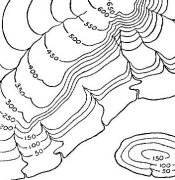 1 Every map has its own special language. The road maps have lines for streets, routes, and highways. The political maps have boundary lines, capital stars, and major cities. For topography maps, the contour lines are the key to understanding this map's special language. Topography is the size and shape of natural and human-made land features. Map projections and globes do not give scientists detailed information about our planet's surface. This is why topographic maps are very useful.
 |
Create Weekly Reading Books
Prepare for an entire week at once! |
| Leave your feedback on Language of Topography (use this link if you found an error in the story) |
|
Earth Science
|
 |
High School Reading Comprehensions and High School Reading Lessons
|
 |
Special Education Science Materials for Teachers
|